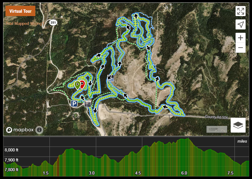
SHSC Course Map
*Course start and finish will be near the Casper Mountain Trails Center 9301 Casper Mountain Rd.*
*Please Note* This is a mountainous trail run consisting of 99% single track trails. Your "road times" do not correlate to trail running.
Course Description
The map was generated using Strava's route function. As such, it sometimes doesn't like new trail sections. So, anybody wanting to run the course before race day note that the route below doesn't follow the course exactly. In reality, on a clockwise loop, you will cross the bridge onto Strube (gravel) and take an immediate right, after approximately 50 yards you will then turn left onto "lower pinball" and follow that all the way until it hooks into "pinball." Other than that, the route leading up to that point and after is accurate. The loop has measured 4.12-4.20 miles and 400-450 feet of gain for one lap. For reference, our TNTR crew just did a group run on the lap and with several stops as well as quite a bit of walking, we finished the lap in just over 56 minutes.
Set amidst the beauty and serenity of Casper Mountain, on forested XC ski and single-track trails. Choose from a challenging 8 mile (2 - 4.17 mile laps) or Backyard Ultra - the same 4.17-mile lap, run every hour on the hour until there is just one runner left standing. Each event starts/finishes in the same location along the Natrona County Parks Multi-Use Trail System.
With course elevations ranging from 7800-8100 feet, this fun yet challenging course will surely enhance what you thought were limitations.
*Please Note* This is a mountainous trail run consisting of 99% single track trails. Your "road times" do not correlate to trail running.
Course Description
The map was generated using Strava's route function. As such, it sometimes doesn't like new trail sections. So, anybody wanting to run the course before race day note that the route below doesn't follow the course exactly. In reality, on a clockwise loop, you will cross the bridge onto Strube (gravel) and take an immediate right, after approximately 50 yards you will then turn left onto "lower pinball" and follow that all the way until it hooks into "pinball." Other than that, the route leading up to that point and after is accurate. The loop has measured 4.12-4.20 miles and 400-450 feet of gain for one lap. For reference, our TNTR crew just did a group run on the lap and with several stops as well as quite a bit of walking, we finished the lap in just over 56 minutes.
Set amidst the beauty and serenity of Casper Mountain, on forested XC ski and single-track trails. Choose from a challenging 8 mile (2 - 4.17 mile laps) or Backyard Ultra - the same 4.17-mile lap, run every hour on the hour until there is just one runner left standing. Each event starts/finishes in the same location along the Natrona County Parks Multi-Use Trail System.
With course elevations ranging from 7800-8100 feet, this fun yet challenging course will surely enhance what you thought were limitations.
Course Map!
|
**ALTERNATING COURSE**
- For the 8 mile option (2 - 4.17 mile laps) - EVEN numbered year = CLOCKWISE DIRECTION - ODD numbered year = COUNTER CLOCKWISE DIRECTION |
For the Backyard Ultra option
- 4.17 mile lap until only 1 runner remains. - After the 8 milers are done, a coin toss will determine each respective laps direction... |